海洋遥感(ocean remote sensing)
Ocean remote sensing (ocean remote sensing)
利用传感器对海洋进行远距离非接触观测,以获取海洋景观和海洋要素的图像或数据资料。海洋不断向环境辐射电磁波能量,海面还会反射或散射太阳和人造辐射源(如雷达)射来的电磁波能量,故可设计一些专门的传感器,把它装载在人造卫星、宇宙飞船、飞机、火箭和气球等携带的工作平台上,接收并记录这些电磁辐射能,再经过传输、加工和处理,得到海洋图像或数据资料。
The use of sensors to make non-contact observations of the ocean at a distance can obtain images or data of the ocean landscapes and ocean elements. The ocean constantly radiates electromagnetic energy to the environment and its surface also reflects or scatters the electromagnetic energy from the sun and artificial radiation sources (such as radar). Therefore, some special sensors can be designed and loaded on the working platforms carried by such tools as artificial satellites, spacecrafts, airplanes, rockets and balloons to receive, record, transmit and process the electromagnetic radiation energy, thus getting ocean images or data information.
遥感方式有主动式和被动式两种:①主动式遥感。先由遥感器向海面发射电磁波,再由接收到的回波提取海洋信息或成像。这种传感器包括测视雷达、微波散射计、雷达高度计、激光雷达和激光荧光计等。②被动式遥感。传感器只接收海面热辐射能或散射太阳光和天空光的能量,从中提取海洋信息或成像。这种传感器包括各种照相机、可见光和红外扫描仪、微波辐射计等。按工作平台划分,海洋遥感可分为航天遥感、航空遥感和地面遥感3种方式。
There are two kinds of remote sensing methods and they are activeness and passiveness. The active remote sensing means that the remote sensor emits electromagnetic waves to the sea surface and then extracts ocean information or imaging from the received echoes. Such sensors include side-looking radars, microwave scatterometers, radar altimeters, lidar and laser fluorometer, etc. The passive remote sensing means that sensors only receive the sea surface thermal radiation energy or scattered sunlight and sky light energy to extract ocean information or imaging. Such sensors include cameras, VIRR, microwave radiometers, etc. According to the working platforms, ocean remote sensing can be divided into aerospace remote sensing, airborne remote sensing and ground remote sensing.
海洋遥感技术
Marine remote sensing technologies
——主要包括以光、电等信息载体和以声波为信息载体的两大遥感技术。
The marine remote sensing technologies mainly include two aspects. The first one regards light and electricity as the carriers and the other regards acoustic wave as the carrier.
海洋声学遥感技术是探测海洋的一种十分有效的手段。利用声学遥感技术,可以探测海底地形、进行海洋动力现象的观测、进行海底地层剖面探测,以及为潜水器提供导航、避碰、海底轮廓跟踪的信息。
Ocean acoustic remote sensing technology is a very effective means of detecting the ocean for it can detect the topography of the seafloor, carry out the observation of ocean dynamics phenomenon, carry out the seafloor stratigraphic profile detection, as well as provide information on navigation, collision prevention and seafloor profile tracking for submersibles.
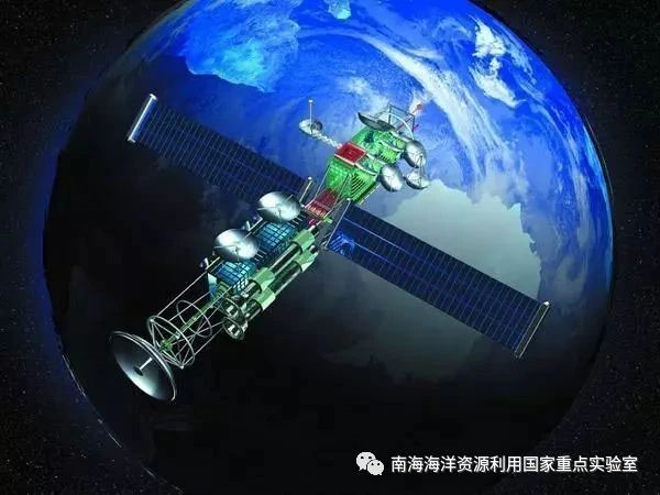
目前,美国、日本、俄罗斯等国已发射了10多颗专用海洋卫星,为海洋遥感技术提供了坚实的支撑平台。
At present, the United States, Japan, Russia and other countries have launched more than 10 special ocean satellites, providing a solid support for ocean remote sensing technologies.

我国正在建立以海洋水色卫星、动力环境卫星、海洋监视监测卫星三大类为主的海洋遥感卫星体系。
China is establishing a system of ocean remote sensing satellites mainly in the three categories of ocean color satellites, ocean dynamical environments satellites and ocean surveillance and monitoring satellites.
用于获取我国近海和全球海洋水色水温及海岸带动态变化信息,重点满足赤潮、渔场、海冰和海温的监测和预测预报需求,遥感载荷为海洋水色扫描仪和海岸带成像仪,可以提供250~1000米空间分辨率的可见光、红外卫星数据。我国已经发射了2颗海洋水色卫星:“海洋一号A”(HY-1A)和“海洋一号B”(HY-1B)。HY-1A属于试验型业务卫星,于2002年5月15日发射成功,结束了我国没有海洋卫星的历史。卫星总计在轨686天。HY-1B为HY-1A卫星的接替星,2007年4月11日发射升空。
It is used to obtain information on the dynamic changes of ocean color and temperature of China’s offshore and global oceans and coastal zones, focusing on meeting the demand for monitoring and forecasting of red tide, fishing grounds, sea ice and sea temperature. The remote sensing payloads which include ocean color scanners and coastal zone imagers provide visible and infrared satellite data with spatial resolution of 250 to 1000 meters. China has launched two ocean color satellites which are HY-1A HY-1B respectively. HY-1A is an experimental operational satellite, which was successfully launched on May 15, 2002, ending the history of no ocean satellite in China. The satellite has been orbiting the Earth for 686 days in total. HY-1B is the successor of HY-1A satellite, which was launched on April 11, 2007.
用于全天时、全天候获取全球范围的海面风场、海面高度、有效波高与海面温度等海洋动力环境信息,遥感载荷包括微波散射计、雷达高度计和微波辐射计等,提供的数据空间分辨率较低(25千米),主要用于满足海洋动力环境预报、海洋灾害预警等要求。2011年8月16日,我国第一颗海洋动力环境卫星“海洋二号”(HY-2A)在太原卫星发射中心成功发射。它集主动、被动微波遥感器于一体,具有高精度测轨、定轨能力与全天候、全天时、全球探测能力,使我国首次具备了全天候、全天时观测海洋的能力。
It is used to obtain global ocean dynamical environment information such as sea surface wind field, sea surface height, effective wave height and sea surface temperature, etc. The remote sensing payloads including microwave scatterometers, radar altimeters and microwave radiometers and so on can provide data with low spatial resolution of 25 km, which is mainly used to meet the requirements of ocean dynamical environment forecasting and ocean disaster warning, etc. On August 16, 2011, China’s first ocean dynamical environments satellite (HY-2A) was successfully launched at Taiyuan Satellite Launch Center. The ocean dynamical environments satellite combines active and passive microwave remote sensors in one and has the abilities of high-precision orbit measurement, orbit determination and all-weather, all-day, global detection, which makes it possible for China to have the all-weather and all-day ocean observation capabilities for the first time.
用于全天时、全天候监视海岛、海岸带、海上目标,并获取海洋浪场、风暴潮漫滩、内波、海冰和溢油等信息,遥感载荷为多极化多模式合成孔径雷达,这一传感器可以不受天气影响提供卫星数据,空间分辨率最高可达米级,但是观测范围有限。
It is used for all-day and all-weather surveillance of islands, coastal zones, marine targets so as to obtain information on ocean wave fields, storm surge inundation, internal waves, sea ice and oil spills, etc. The remote sensing payload is a multi-polarization and multi-mode synthetic aperture radar, which allows it to provide satellite data regardless of weather. Its spatial resolution can be up to the meter level, but its observation range is limited.
(图片来源于网络,如有侵权,联系我们删除)
 公众号
公众号